Discover the coast on foot
-
![]()
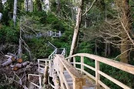
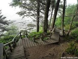
Tonquin Trail
Summary: A moderately challenging trail that leads through lush rainforest to Tonquin Beach, offering a mix of forest scenery and coastal views.
Location: The beach can be accessed via two entry points: the Tonquin Beach Trail, which leads down a boardwalk and a series of stairs from Tonquin Park Road, and from the Tonquin Trail near the Tofino Community Hall. -
![]()
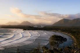
Cox Bay Loop Trail
Summary: A short, vertical loop trail providing stunning views of Cox Bay, suitable for families and casual hikers. Watch for the mud!
Location: Near Cox Bay, just a few minutes from Tofino’s town center. -
![]()
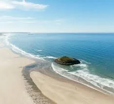
Long Beach
Summary: A flat trail running along the expansive Long Beach, ideal for leisurely strolls and beach-combing.
Location: Within Pacific Rim National Park, about 30 minutes from Tofino. Park at Incinerator rock and being your journey south! -
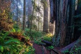
![]()
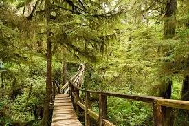
Rainforest Trail
Summary: An educational trail showcasing the temperate rainforest ecosystem with boardwalks and interpretative signs.
Location: Within Pacific Rim National Park, about 30 minutes from Tofino. -
![]()
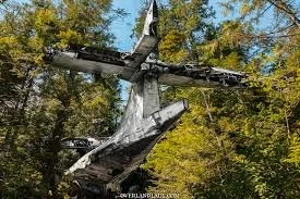
Bomber Trail to Abandoned Airplane
Summary: A rugged hike leading to a World War II-era airplane wreck set in a beautiful forested area.
Location: From the lower parking lot at Radar Hill, walk to the paved path and head south a short distance until you reach the trailhead to the Canso Plane Crash. -
![]()
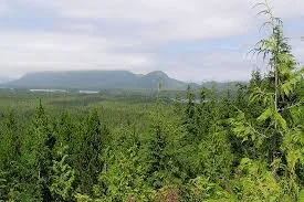
Radar Hill
Summary: A moderately challenging hike with panoramic views of the coastline and mountains from the top.
Location: Located in Pacific Rim National Park, just a short drive from Tofino. -
![]()
Florencia Bay
Summary: This trail leads through lush forest to the beautiful Florencia Bay, ideal for a peaceful beach experience.
Location: Part of Pacific Rim National Park, turn on Willowbrae Road, and the parking lot and trailhead are at the end of the road. -
![]()
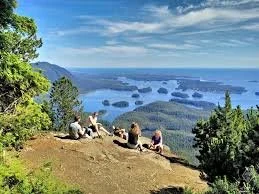
Lone Cone
Summary: A challenging hike that ascends to the summit of Lone Cone Mountain, offering breathtaking views of Clayoquot Sound. About 6 hour hike.
Location: Accessible via a boat ride from Tofino to Meares Island. -
![]()
Meares Island Big Tree Trail
Summary: This loop trail features some of the largest and oldest trees in the area, with informative signage about the local ecology.
Location: Located on Meares Island, accessible by water taxi from Tofino. -
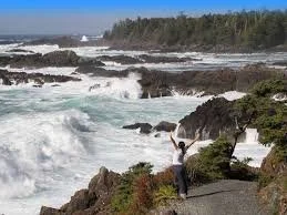
![]()
Wild Pacific Trail
Summary: A scenic coastal trail with breathtaking views of the Pacific Ocean and rugged coastline, featuring several loops suitable for all skill levels.
Location: Begins in Ucluelet, just a short drive from Tofino. Many access points. -
![]()
Light House Loop
Summary: A short, scenic loop that takes you to the Ucluelet Lighthouse, offering stunning coastal views and a chance to see marine wildlife.
Location: Located in Ucluelet, easily accessible from the town center. 1002 Peninsula Rd. -
![]()
Mount Ozzard
Summary: A moderately challenging hike that rewards you with panoramic views of Ucluelet and the surrounding ocean. 6.5-mile out-and-back trail.
Location: Take the first left onto Port Albion Road. if you’re driving from Ucluelet this is the last right before the junction. At the turnoff there are signs for Mussel Beach Campground. Continue along Port Albion road for 4km before turning left onto Barkley Road. Continue for another 2 km before turning left just after crossing a small bridge over Mercantile Creek. From here the road gets a bit too rough for some vehicles, so I parked at a pullout on the left side of the road instead of driving the next 700m.